Overview
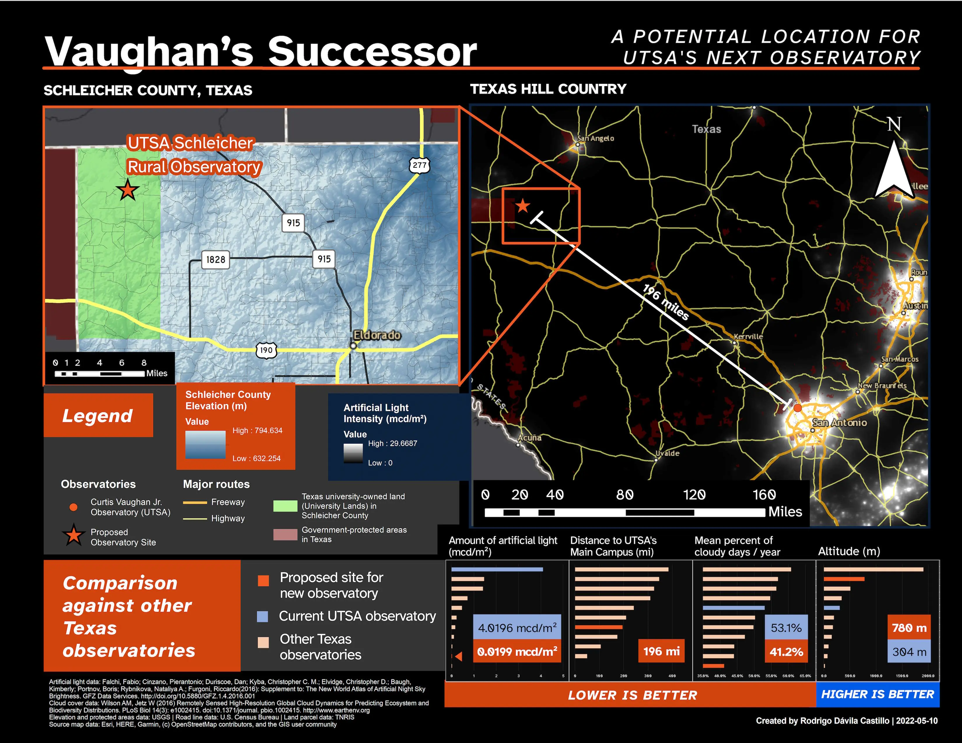
"Vaughan's Successor" is a GIS analysis project, conducted by me in the spring 2022 semester for the Fundamentals of GIS course at UTSA (ES 2113).
For this semester project, I looked to implement my GIS knowledge towards a practical purpose—originally, I looked to put together a project that would find a suitable location for a train line connecting parts of the city. However, given the huge number of socio-economic factors to consider for such a project, I felt that it was too ambitious for only me to work on. Therefore, I instead explored a different proposal that would instead serve my university's scientific community; specifically, I knew that we had an observatory on campus, whose telescopes’ clarity has been affected due to increasing light pollution around the city’s northwest. Therefore, I looked into finding the specific criteria for an astronomical observatory site, and felt that I could feasibly come up with a proposal that fulfilled these criterial, using public geospatial data.
Government and academic sources were the most useful sources of data for this project—elevation data from USGS, road data from the U.S. Census Bureau, land parcel data from TNRIS, and light pollution data alongside cloud cover data from academics was used to determine the Schleicher County site. I found it fairly challenging to work this data due to its magnitude, with some image files taking up multiple gigabytes on my computer. However, I found it challenging to work with this data due to its magnitude, with some image files taking up multiple gigabytes on my computer. Despite this, I pushed on with the data, and at the end I was able to package only the files I used in the final presentation poster, shown above.
The land parcel data was particularly enlightening—browsing the data led to my discovery of the University Lands, which are lands already held by the public Texas university system to generate funding. This led me to believe that choosing a parcel already belonging to the University system would be an attractive aspect of a candidate site, leading me to Schleicher County.
Once I found the area, I compared it with other existing Texas observatory sites to justify the existence of the Schleicher observatory; I was ultimately able to use the existing data I had on hand (e.g., the geospatial image showing light pollution levels) to show the superiority of my proposed site, allowing me to make a more persuasive argument with my data.
In the end, I felt very confident in my proposal—I found a way to put my skills towards a practical purpose. I was initially drawn to GIS due to the practicality and social benefits that can come from the technology, as exemplified by my GIS textbook, which outlined the steps in finding a site for a public park for under-served communities. Ultimately, this project helped me realize that vision—and I hope my work can ultimately serve my community in the future.
Methods used
Skills
- Ability to research and find public geospatial data to answer a research question
- Database retrieval skills, critical in finding and downloading data from government data archives
- GIS principles for effectively using and creating GIS data to perform an analysis with geospatial data
- Proficiency in using GIS analysis software (ArcMap) and its geoprocessing functions to achieve my research goals
- Ability to look through forums and other communities to find solutions to technical problems (e.g., ArcMap issues with raster data)
- Graphic and layout design techniques, so as to put together an informative poster that justifies the proposed site
Software, tools, and libraries
Project files
Download full poster image (.png)Media credits
Article thumbnail and presentation poster created by me. ArcMap icon is "Earth Search" from the Streamline Regular icon pack, designed by Streamline.
